William T. Gaulding: Land Transactions and Property Location

Following his Revolutionary War service, William T. Gauldin reported that he remained in Bedford County for eight years before gradually relocating into Pittsylvania County. (1) During this transitional period, he continued to appear on the Campbell County Personal Property Tax Lists from 1786 to 1791, where he was taxed on two horses but no tithes, suggesting that although he no longer lived in Campbell County, some of his livestock remained there.
By 1791, William had begun acquiring land in Pittsylvania County (19,25), marking the beginning of his permanent settlement there. His first Pittsylvania County land purchase occurred on 13 July 1791, when John and Mary Buckley conveyed to him, for 30 pounds, a tract of land—acreage not stated—located at the head of the South Branch of Stuart’s Creek, adjoining the property of John Childress (DB 9:208). The deed identified him as “of Campbell County,” showing that his move into Pittsylvania was gradual rather than immediate.
Over the next several decades, William steadily expanded his holdings along Stewart’s Creek. On 12 February 1829, he purchased 57¾ acres from Richard and Rebecca Holland for $150, a tract adjoining the lands of Richard Breedlove and the estate of George P. Wells, deceased (DB 30:548). This acquisition represents the first documented expansion of his Pittsylvania farm. Four years later, on 15 November 1833, he added another 142 acres purchased from James and Lucy Beck for $97, also situated on the branches of Stewart’s Creek and adjoining his own land as well as that of William M. Tarpley and Richard Breedlove (DB 35:379). This purchase significantly enlarged his farm and demonstrates his long‑term strategy of consolidating a large, contiguous agricultural estate. A final recorded transaction occurred on 12 July 1839, when William and his second wife Malissa (Dicey) Gauldin sold to Jabez S. Dallas the entire tract he had originally purchased from Richard Holland—approximately 58 acres—for $200, land bounded by the properties of Richard Breedlove and Dallas himself (DB 43:58).
Census records confirm William’s long residence in Pittsylvania County: he appears in the 1820, 1830, and 1840 federal censuses, though he is absent from the 1810 census, which is missing for the county. His first wife, Margaret Lane, was born between 1760 and 1770 and died between 1830 and 1834 (#85). Her surname was identified through testimony in the Gauldin chancery suit, first located by Ronnie Walker, who also found evidence that Margaret’s mother may have been named Mary, though the supporting citation for that detail has not yet been located.
Taken together, these tax entries, census appearances, and land transactions (8) reveal a clear pattern of migration and settlement: William T. Gauldin moved southward from Bedford into Campbell County and finally into Pittsylvania County, where he spent decades building and expanding a substantial farm along Stuart’s Creek—property that would anchor the Gauldin family in the region for generations.
Date | People named | Transaction |
1791 | Mary Buckley to William T. Gaulding, John Childress | 1791 Jul 13 Pittsylvania Co., VA....John; Mary Buckley to William T. Gaulding of Campbell Co. for 30 lbs...(no acres given ) tract on head of the South Branch of Stuart's Creek adj. John Childress (DB 9:208) |
1792 | William T. Gaulding, John Buckley | 1792 William T. of Campbell Co John Buckly; wife--a on Stuarts Cr 34-388 |
1829 | Richard Pitts, Rebecca Holland to William T. Gaulding, Richard Breedlove, George P. Wells | 1829 Feb 12 Pitts...Richard; Rebecca Holland to William T. Gaulding for $150...57 3/4 a adj Richard Breedlove & George P. Wells dec'd (DB 30:548) 12 Feb. 1829-Holland to Gauldin-Pittsylvania Co., VA-Richard and Rebecca Holland TO William T. Gauldin for $150..57 3/4 acres adjoining Richard Breedlove and George P. Wells, decd. (DB 30:548) |
1829 | William T. Gaulding, Richard Holland, McDaniel | 1829 William T. Richard Holland; wife 57 3/4 a. McDaniel; wf 165 a Cascade Cr 35-379 |
1833 | James Pitts, Lucy Beck to William T. Gauldin, William M. Tarpley, Richard Breedlove | 1833 Nov 15 Pitts...James; Lucy Beck to William T. Gauldin for $97...142 a on BS Stuart's Creek adj. sd Wm T. Gauldin, Wm. M. Tarpley; Richard Breedlove (DB 35:379) |
1833 | William T. Gaulding, James Beck to Gaulding, James and Lucy Beck, William M. Tarpley, Richard Breedlove | 1833 William T. James Beck Grantee Galding 52-459; 15 Nov. 1833-Beck to Gauldin-Pittsylvania Co. VA- James and Lucy Beck TO William T. Gauldin for $97..142 acres on BS Stuart's Creek adjacent sd William T. Gauldin, William M. Tarpley and Richard Breedlove (DB 35:379) |
1833 | Samuel Benjamin Watkins | 1833 Samuel Benj Watkins Admr. et al 69a +50a Cascade 46-140 1842 |
1839 | William T. Gaulding to J.L. Dallas, Malissa Gaulding, Jabez S. Dallas, Richard Holland, Richard Breedlove | 12 July 1839-William T. TO J.L. Dallas-Pittsylvania County, Virginia --Indenture made ..between William T. Gauldin and Millisy Gaulding his wife of the County of Pittsylvania and Jabez S. Dallas of the said county, witness that whereas for the consideration of $200 to the said William T. Gauldin. The entire tract of land which be the said Gaulding purchased by Richard Holland and wife containing by estimate 58 acres.. bounded by the lands of Richard Breedlove and the said Dallas.."(DB 43:58) |
1850 | Halzlip | 1850 John W. William H. Halzlip; wife Grantee Gaulding to 1852 |
When we go to the 1830 U.S. Census for Pittsylvania County, we see many of these names in the list of the closest neighbors to William T. Gaulding. (1)
Samuel Uhles - The Gaulding and Uhles Family have a connection through marriage in both the 19th and 20th century. |
Mary Bray - The Gaulding and Bray family have a close family connection through marriage in both the 19th and 20th century. |
C. Sholmate (?) Shumate? |
William Tarpley - He appears in land records: 1833 Beck → Gauldin, land adjoining William M. Tarpley (DB 35:379) He also appears in 1830 neighbors list. Tarpley was another adjacent landowner. His appearance in the 1830 census list confirms that he lived close enough to be enumerated near William. Along with William T. Gaulding, William Tarpley was one of the wealthiest individuals both in land and slaves. |
Joel Matherly |
Elliott, Woodall, and Gauldin Family Connections Appears in 1830 neighbors list: Jonathan Elliott James Elliott - This was Nancy Gaulding’s husband. Nancy was the illegitimate daughter of Margaret Lane Gaulding, the first wife of William T. Gaulding. C.M. Woodall John Woodall Andy Gauldin (William’s son) William Gauldin (likely William Jr.)
These names do not appear in the land transactions, but they appear in the 1830 census because: The Elliotts were connected through Nancy Gaulding, Margaret Lane’s illegitimate daughter. The Woodalls were connected through Elizabeth Gaulding Woodall, William’s daughter. Andy Gauldin and William Gauldin were William’s sons. These families lived very close to William, forming a cluster of kinship households typical of rural Virginia. |
David W. Breedlove – Related to Richard Breedlove. |
William T. Gauldin – In the 1830 census, the household of William T. Gaulding was comprised of 2 free persons (William and his wife Malissa) and 13 slaves. He was one of the wealthiest residents of the area. |
N.H. Taliafino |
John McCune |
James Beck - Appears in land records 1833 James & Lucy Beck → Gauldin (DB 35:379). He also appears in 1830 neighbors list. James Beck was not only a neighbor but also a seller of land to William. His presence in both the deed and the census confirms that William was purchasing land from people who lived immediately around him. |
Richard Breedlove - Appears in land records: 1829 Holland → Gauldin, land adjoining Richard Breedlove (DB 30:548) 1833 Beck → Gauldin, land adjoining Richard Breedlove (DB 35:379) 1839 Gauldin → Dallas, land bounded by Richard Breedlove (DB 43:58) Appears in 1830 neighbors list.
Breedlove was one of William’s closest long‑term neighbors. His name appears repeatedly as a boundary marker over a span of at least 10 years, confirming that the Breedlove family lived adjacent to William on Stuart’s Creek. This also aligns with the presence of David W. Breedlove in the 1830 list—likely a relative. |
John Fowlkes |
Moses Herndon - The Gaulding and the Herndon Family married well into the 20th Century. |
James Watkins - Appears in land records: 1833 Samuel Benjamin Watkins, administrator (DB 46:140) Appears in 1830 neighbors list.
While the deed references Samuel Benjamin Watkins, the census lists James Watkins. These are likely members of the same Watkins family, indicating that the Watkinses lived in the same community and were involved in land administration and estate matters. |
William N. Perkins |
Corban Francis |
Henry Innman |
William Pritchete |
John Heanie |
James Blair |
Thomas Sparks |
Issac Harvey |


Stewart’s Creek and the Old Carolina Road
Stewart's Creek
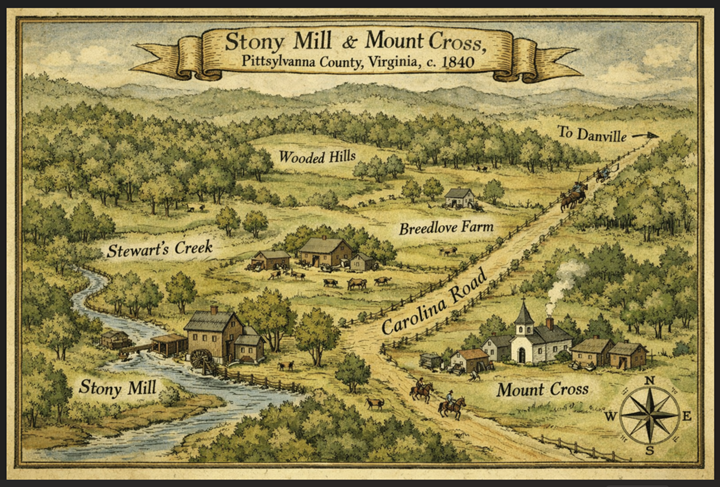
Stewart's Creek is a real, surviving, and still-named waterway in Pittsylvania County — it has not been lost or renamed. Its USGS coordinates place it at approximately 36.648°N, 79.547°W, appearing on the Whitmell, VA topographic quadrant, near the tiny community of Stony Mill, roughly 9–10 miles west-northwest of Danville. It also has a named tributary — Little Stewart Creek — flowing about 1.3 miles to its north, which speaks to the creek's size and local significance. Nearby streams include Silver Creek, Hardy's Creek, and Sugartree Creek. (3)
The earliest documented reference to the creek predates Pittsylvania County itself. In 1746, when this territory was still part of Lunenburg County, Cumberland Parish ordered a Church of England chapel to be built on Stewart's Creek — one of the very first church sites in the region. (3) “The life of the English church began in this section with the formation of Lunenburg County and Cumberland Parish in 1746. In the first two years seven churches were built, one being on Stewart's Creek, and another Peter's Creek Chapel (which today is a Methodist church).” (3)
Pittsylvania County wasn't organized until 1767, meaning Stewart's Creek was already a named, settled landmark at least two decades before the county existed. That early church reference is genealogically significant: it confirms the creek was a focal point for early settlement and community organization in the area where the Gauldin family later acquired land.
The name almost certainly derives from a person named Stewart (or Stuart) — a common pattern for Virginia stream names — though the specific individual has not been definitively identified. Given the creek's location near Whitmell and Brosville, it sits in the same general neighborhood as the Gauldin-cluster deeds (especially DB 30:548 and DB 35:379), making it a plausible natural boundary or descriptive reference in those transactions.
Strawberry Creek, on the other hand, got it’s name from an area plantation. Strawberry Creek is where some of the descendants of William T. Gaulding settled. “The house of Samuel Harris was situated on Strawberry Creek of Banister River near Whitmell. He was a man of wealth, and in 1777 paid taxes on 4,000 acres of land and on ten slaves. He built a large new frame building for worship which became known as the Strawberry Meeting House. When the counties of Patrick, Henry, Bedford and Pittsylvania were formed into an Association, it was given the name of Strawberry in honor of Harris' home. Harris was held in the highest esteem by the church. From the time of the organization of the Virginia Association in 1771 until overcome with age, about 1790, he served as moderator of the meetings of the Association. When in 1774 it was decided that the church should have a head, he was chosen as the Apostle of Virginia. The office was abolished at his request. He died in 1799 and is buried on his Strawberry plantation.” (3)
Strawberry Creek and Stewart’s Creek are on different watersheds and are not the same stream in Pittsylvania County.
The Carolina Road
The Carolina Road appearing in Pittsylvania County deeds was one of the most consequential transportation corridors in colonial and early American history. Formally described as extending "from Lancaster, Pennsylvania to the Yadkin Valley" in North Carolina, it was the primary overland migration route for tens of thousands of Scotch-Irish and Swiss-German settlers pushing south and west from the 1740s onward. (3)
In Southside Virginia — the region that includes Pittsylvania County — the road ran east of the Blue Ridge Mountains, cutting through the backcountry toward the Virginia-North Carolina border. Settlers traveling it carried manufactured goods southward (woolens, leather goods, harness) and returned north with hides, indigo, and currency. It also served droves of livestock — cattle, swine, sheep, and even turkeys — so heavily trafficked that farmers to the north nicknamed it "Rogues' Road" because drovers were known to absorb local animals into their herds. (3)
For Pittsylvania County specifically, the historian Maud Carter Clement confirms the road passed through the region, and the late 1830s Franklin Turnpike — connecting Danville to Fincastle in Botetourt County — was built largely along the same corridor. (3)
In practical terms, the Carolina Road in the Gauldin-era deeds (c. 1791–1839) was the principal north-south artery through Pittsylvania, roughly tracing what is now the US Route 29 corridor near Danville. When it appears as a boundary call in a deed, it was not a minor country lane — it was a well-established, widely recognized public road, likely carrying commercial and migration traffic throughout William Gauldin's lifetime.
Genealogical implication: Land described as adjacent to or bounded by the Carolina Road was typically well-situated for commerce and community. The Gaudin family holding land near this artery suggests they were positioned at or near a meaningful crossroads of activity in the county.
Where was William T. Gaulding’s property located?
While it really isn’t possible to give GPS coordinates from deed references along, it is possible to triangulate a well-reasoned approximate location from the two named landmarks (Stewart's Creek + Carolina Road) and the 1830 neighbor cluster.
Combining everything — Stewart's Creek coordinates, the Carolina Road corridor, the Whitmell topo quad, ZIP 24069, and the neighbor cluster — the Gauldin property almost certainly lay in this zone:
Approximate center point: 36.650°N, 79.513°W
Modern community: Stony Mill / Mount Cross, VA
~9–11 mi WNW of Danville
USGS Topo Quad: Whitmell, VA
Works Cited
1. William T. Gaulding Pension Application. [Online]
2. 1830 U.S. Federal Census. ancestry.com. [Online] Pittsylvania County. https://www.ancestry.com/imageviewer/collections/8058/images/4411349_00737?pId=956148.
3. Stewart's Creek. Anyplace America.com. [Online] https://www.anyplaceamerica.com/directory/va/pittsylvania-county-51143/streams/stewart-creek-1475132/.
4. An Abbreviated History of Pittsylvania County, Virginia. victorianvilla.com. [Online] Chapter Nine: Church Development, By Maud Carter Clement, Chatham, Virginia, ca. 1952. https://www.victorianvilla.com/sims-mitchell/local/clement/mc/abb/09.htm.
5. Chancery Suit. [Online] https://www.lva.virginia.gov/chancery/full_case_detail.asp?CFN=143-1852-0 23#img.
6. Carolina Road. Wikipedia. [Online] https://en.wikipedia.org/wiki/Carolina_Road.
7. The Carolina Road. Virginia Places. [Online] https://virginiaplaces.org/transportation/carolinaroad.html.
8 Catherine L. Gauldin, The Gaulding Family of Pittsylvania County, Virginia (Self-published 2000), Catherine Gauldin, From the Land Office Records, Pittsylvania County, Virginia: (Pittsylvania County Index, Galden-Gaulden VSL 4/84) INDEX TO GRANTEE 1767-1889 GALDIN 30-548 9-208. I personally accessed all of these land transactions and deeds at the Pittsylvania County Archives in Chatham, Va in about 1986.
© 2026 Catherine L. Gauldin, Gaulding Origins. All original content protected. Use of this site implies agreement with the Terms of Use and Privacy Policy.


Comments